Category: news

Who Knows Your Lake?

by Hanna Edelglass

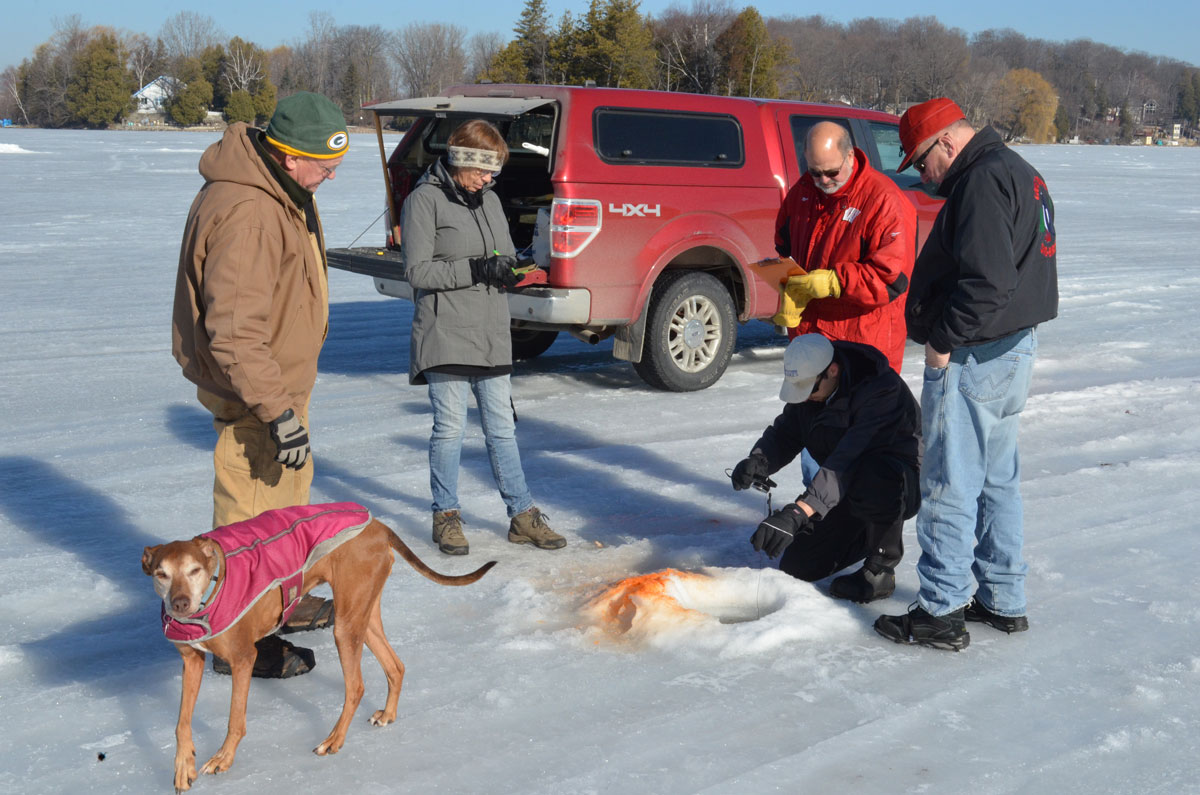
Have you ever wondered how sloshing around, ankle deep in water, on top of a sheet of ice, helps you to get to know your lake? We were drilling holes into the ice, angling for plants and small organisms, finding where the fish are and why they are there and each answer only brings more questions. Such as, why are these plants here? And what is their effect on the water, on fishing, on boating and swimming, property values, even the local economy? We explore and work to find out how all this relates to what flows into this lake, which can create positive or negative change, upsetting or healing its natural balance. This is the purpose of our scientific endeavor. I learnt some of that on the ice with Manitowoc County’s Cedar Lake residents and Paul Skawinski (an Aquatic Biologist and Outreach Specialist for UW-Extension) in February of this year. And yes, I wore warm, waterproof boots.

New Interactive Watershed Mapping Tool

UPDATED APRIL 21, 2017. Bruce Riesterer, Resource Conservationist at the Manitowoc County Soil and Water Conservation Department, has created a new, interactive, watershed mapping tool. Click here to use it to view the watershed for your lake.

Private and public lake watersheds are displayed, with a choice of base maps that includes terrain, street maps, satellite and others.

The new mapping shows the watershed land area and boundaries quite clearly. Because the water quality of each lake is affected by things happening in this area, this new level of precision is quite helpful! The boundaries are now more accurate because of new lidar-generated elevation data recently made available.

The image shown here is a great example of the new level of detail this tool provides, as evidenced by the watershed boundaries for Tuma Lake. The light blue area is the watershed according to previous maps. The bright green is the watershed as drawn by the new mapping tool.

On the actual mapping tool website (http://manitowoc.maps.arcgis.com/apps/View/index.html?appid=c38b2149d3b947eb9bd120f5480c4a1e) the user can zoom in to show an extreme level of detail, as shown in the second image.

Bruce asks that people take a look at the watershed for their lake(s) and let him know immediately if they see something that doesn’t seem accurate (e.g., placement of culverts). You can contact him at bruceriesterer@co.manitowoc.wi.us

TMDL Meeting Monday, April 17

Please attend and hear the DNR explain this very important issue that affects our natural resources in the Manitowoc area.
The informational meeting will include a presentation from DNR staff as well as a question and answer session. Representatives Paul Tittl (R-Manitowoc) and André Jacque (R-De Pere) will be in attendance, and would be honored if you could attend.

TMDL issues and phosphorus runoff in the Northeast Wisconsin watershed. 
Monday, April 17 at 10:30am
Manitowoc County Office Complex
4319 Expo Drive, Manitowoc WI 54220

MCLA has been an early advocate of the Total Maximum Daily Load (TMDL) modeling, as an essential step toward enhancing the quality of area lakes and watersheds. The DNR, the County Soil and Water Conservation Department, and LNRP are actively pursuing the establishment of a TMDL program in Manitowoc County. Several area legislators are considering the establishment of a much larger area of study, covering essentially the whole of Northeast Wisconsin. They are holding listening sessions to ascertain public support for the program.

If you cannot make the meeting, you can improve your waters by contacting your State legislators expressing support for the program.   

AIS Monitoring Kits to Be Distributed May 30

Paul Skawinski, the AIS Citizen Monitoring Coordinator for the state will be coming to Cedar Lake on May 30, 2017, to talk about his program.  At that time, he will also be distributing AIS monitoring kits to any lake that is interested in having one.  He will only give one kit per lake due to […]

Expanded Lake Michigan lake trout harvest takes effect April 15

lake trout

Expanded lake trout harvest opportunities will take effect Saturday, April 15 in the Wisconsin waters of Lake Michigan thanks to an emergency rule approved by the Wisconsin Natural Resources Board, increasing the daily bag limit from two to five lake trout. Other provisions include: counting the five fish daily lake trout limit as part of the overall five trout and salmon combined daily bag limit; maintaining closure of refuges, which are supporting some natural reproduction; and offering a continuous open season in 2017.

Get Your License and Go Wild!

Get your license and Go Wild!

Anglers are reminded that the new license year began April 1 for waters or species with a continuous open season. Licenses and stamps for the 2017 year are on sale now through GoWild.Wi.Gov. Fees for the 2017 license year remain the same as last year.

Anglers fishing Lake Michigan and all other Wisconsin boundary waters are again reminded they must possess a paper copy of their license to be legal. The paper printouts are required so law enforcement officials in the surrounding states can verify compliance with license and stamp regulations.

More information about length and bag limits as well as places to fish can be found on the DNR website.

“Life Beneath the Ice”

An Event Report By MCLA Member Hanna Edelglass March 7, 2017—On Friday, the 17th of February, Paul Skawinski, Coordinator of the Wisconsin Citizen Lake Monitoring Network, UW Extension Lakes Program University of Wisconsin; Stevens Point, hosted an all day Citizen Lake Monitoring Network meeting with volunteers, sponsored in conjunction with Sanitary District #1, Cedar Lake. The […]

Emergency Lake Michigan Trout Rules in Effect

March 1, 2017—The Wisconsin Natural Resources Board today approved an emergency rule regarding bag limits and season length on lake trout for Lake Michigan. The rule increases lake trout daily bag limits to five 10″ fish on Lake Michigan waters with open season from March 1–Oct 31. The previous limit was two fish. This does not change the […]

Paul Skawinski at Cedar Lake on Feb 17th

Updated Feb. 26, 2017—PAUL SKAWINSKI, Coordinator Wisconsin Citizen Lake Monitoring Network UW Extension Lakes Program University of Wisconsin-Stevens Point, sponsored in conjunction with Sanitary District #1, Cedar Lake. Originally published Feb. 14, 2017. Paul will host a Citizen’s Lake Monitoring Network meeting with volunteers, and will resume the sampling at Cedar Lake on Friday, Feb. 17. Anyone […]

Paul Skawinski Cancellation

February 9, 2017–Please note all Feb. 9 & 10 events scheduled with guest Paul Skawinski have been cancelled due to illness. The Cedar Lake sampling will take place Friday, Feb. 17 at 9:00am. The presentation will be rescheduled.

A Model for Manitowoc? The Ozaukee County Fish Passage Program

July 2016–Andrew Struck, Director of Planning and Parks in Ozaukee County, has orchestrated a highly successful County-initiated Fish Passage Program. The program set a goal of reconnecting streams, marshes, flood plains, wetlands, and waterbodies so as to allow native fish and other aquatic populations to find spawning grounds, habitat, and seasonal survival areas. The County […]